Geophysical Magnetic Anomaly Map
The University of Glasgow team have produced a magnetic anomaly map from the data collected in the survey, shown below superimposed over the aerial photograph. The linear feature shown on Scobie’s 1783 map is visible both in the magnetic anomaly and the aerial photograph, as is the rectangular earthwork. Over to the west is an area of significant disturbance in the magnetic anomaly, corresponding to an area of what have been described as ‘cists’.
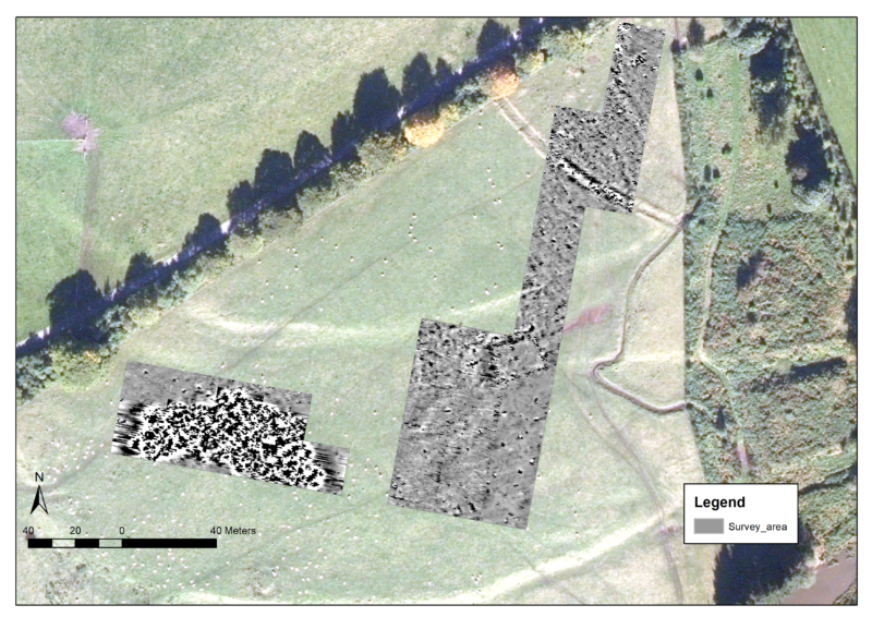
The magnetic anomaly and aerial photograph show features that correspond well with the LiDAR survey.
Anouk Busset, Adrián Maldonado, Megan Kasten and Scott T. McCreadie have written that the “area appeared on the surface as rather stonier than the surrounding field, and the geophysical survey shows that this is very dissimilar to the local geology. Because this was only glimpsed in this transect, the full shape and extent of this feature remains unknown, but it appears crescentic, quite unlike the round and long cairns already attested in this field … It is also level, unlike the clearly mounded profiles of the other prehistoric features.” They go on to say that “… the survey also inevitably raised questions that cannot at this time be answered. This mainly relates to the massive, highly magnetic anomaly to the west of these features. At this stage, its size and shape cannot be fully determined and requires further geophysical survey and test pitting to rule out a geological explanation, though any survey further to the south would quickly encroach on the scheduled monument extent to the cairn to its south and would require consent from Historic Environment Scotland before work could proceed in this direction. Certainly its size would make it a major monument if it is archaeological, but its lack of height and near invisibility on the surface is puzzling given the survival of large upstanding cairns nearby.”
Show the Map